Jeff Frame's avatar

Jeff Frame

@vortexjeff.bsky.social

540 followers 362 following 652 posts

Teaching associate professor of atmospheric sciences at the University of Illinois. I teach weather. Storm chaser. PhD, MS PSU; BS Michigan. All opinions mine.


Jeff Frame's avatar Jeff Frame @vortexjeff.bsky.social
[ View ]

Fine for now because mid/late June were quite dry. Over 4.5" of that rain fell in the last two days as well. I doubt it will stay that way though.

0 replies 0 reposts 1 likes


Jeff Frame's avatar Jeff Frame @vortexjeff.bsky.social
[ View ]

Picked up another 0.76" rain yesterday, making over 6 inches of rain in my Urbana backyard in the last week.

1 replies 0 reposts 3 likes


Jeff Frame's avatar Jeff Frame @vortexjeff.bsky.social
[ View ]

Local chase featuring scud and SLCs

0 replies 0 reposts 3 likes


Reposted by Jeff Frame

Jimmy Yunge's avatar Jimmy Yunge @jimmy-yunge.bsky.social
[ View ]

Important for the public: tornadoes do not "touch down"! πŸŒͺ "Funnel clouds, which build downward from the thunderstorm cloud, are often mistaken for a 'descending' tornado... the tornado itself is found in *ascending* air, and the rotation rate is usually similar throughout the whole column." 1/

2 replies 3 reposts 7 likes


Jeff Frame's avatar Jeff Frame @vortexjeff.bsky.social
[ View ]

4.34" rain from Beryl in Urbana, IL!

0 replies 0 reposts 2 likes


Reposted by Jeff Frame

Brian McNoldy's avatar Brian McNoldy @bmcnoldy.bsky.social
[ View ]

This radar loop begins when #Beryl made landfall and spans 21 hours: bmcnoldy.earth.miami.edu/tropics/bery...
It illustrates the nearly 100 tornado warnings (red polygons) that were issued as the rainbands moved inland... and as usual, the vast majority occurred in the storm's front-right quadrant.

1 replies 6 reposts 19 likes


Reposted by Jeff Frame

Reposted by Jeff Frame

Weather History's avatar Weather History @weatherhistory.bsky.social
[ View ]

It is believed the first confirmed tornado death in the United States occurred on July 8th, 1680 near Cambridge, Massachusetts. Judge Samuel Sewall wrote in his diary, "in the afternoon a whirlwind ariseth, near Samuel Stone's." It "kills John Robbins, who was at hoe, breaking his arm and jawbone."

1 replies 1 reposts 3 likes


Reposted by Jeff Frame

Mark Ellinwood's avatar Mark Ellinwood @markellinwood.bsky.social
[ View ]

Hurricane Beryl landfall near Matagorda, Texas.

0 replies 2 reposts 0 likes


Reposted by Jeff Frame

Reposted by Jeff Frame

Alex Lamers's avatar Alex Lamers @alexlamers.bsky.social
[ View ]

Two exceptional all-time heat records were set today. 124Β°F in Palm Springs, CA and 106Β°F in Raleigh, NC. Heat wave is really just beginning to ramp up in the West too.

0 replies 5 reposts 8 likes


Reposted by Jeff Frame

Jeff Frame's avatar Jeff Frame @vortexjeff.bsky.social
[ View ]

Anyway, here are a couple of #BadPhone pictures from the Champaign fireworks tonight

0 replies 0 reposts 1 likes


Jeff Frame's avatar Jeff Frame @vortexjeff.bsky.social
[ View ]

Fireworks are much more enjoyable when you don't bring your camera

1 replies 0 reposts 2 likes


Jeff Frame's avatar Jeff Frame @vortexjeff.bsky.social
[ View ]

Beautiful afternoon at Homer Lake. If you look closely at the last image, there's a large bird taking flight near the shoreline in the middle of the image

0 replies 0 reposts 2 likes


Reposted by Jeff Frame

Alex Lamers's avatar Alex Lamers @alexlamers.bsky.social
[ View ]

β€œOn the islands of Carriacou and Petite Martinique β€” ground zero for Hurricane Beryl’s 150-mph eye β€” the toll is catastrophic: an estimated 95 percent of the homes are heavily damaged and likely uninhabitable.” www.miamiherald.com/news/nation-...

1 replies 5 reposts 6 likes


Reposted by Jeff Frame

Ian Livingston's avatar Ian Livingston @ianlivingston.bsky.social
[ View ]

Sun rising on Category 5 Hurricane #Beryl. 165 mph sustained wind, strongest storm so early in the season on record in the Atlantic. #tropicalwx

1 replies 25 reposts 32 likes


Reposted by Jeff Frame

Brendon 🐻πŸŒͺ️❄'s avatar Brendon 🐻πŸŒͺ️❄ @brendonme.bsky.social
[ View ]

Beautifully structured supercell in Cheyenne WY yesterday

2 replies 3 reposts 19 likes


Reposted by Jeff Frame

Ian Livingston's avatar Ian Livingston @ianlivingston.bsky.social
[ View ]

Some more #HurricaneBeryl satellite spam. Although tbh it is quite stellar in appearance and circleness. Always the sunset shot.

1 replies 1 reposts 8 likes


Reposted by Jeff Frame

Jeff Frame's avatar Jeff Frame @vortexjeff.bsky.social
[ View ]

I initially read this as "500 millibars" and was very confused.

0 replies 0 reposts 5 likes


Reposted by Jeff Frame

Alex Lamers's avatar Alex Lamers @alexlamers.bsky.social
[ View ]

Bad time for explosive intensification of Beryl, with the Windward Islands now in the frame. A major hurricane now on Sunday morning, and the big questions are how much stronger it gets before reaching the islands, and where exactly the inner core tracks.

2 replies 5 reposts 8 likes


Reposted by Jeff Frame

Brendon 🐻πŸŒͺ️❄'s avatar Brendon 🐻πŸŒͺ️❄ @brendonme.bsky.social
[ View ]

One year ago today near Kimball, Nebraska

2 replies 2 reposts 10 likes


Reposted by Jeff Frame

BNO News's avatar BNO News @bnonews.com
[ View ]

BREAKING: Tropical Storm Beryl forms in the Atlantic, heading towards the Caribbean

0 replies 4 reposts 10 likes


Reposted by Jeff Frame

Randall Munroe's avatar Randall Munroe @xkcd.com
[ View ]

#79: Where each country SHOULD be, according to its time zone(s) xkcd.com/1799

8 replies 48 reposts 492 likes


Reposted by Jeff Frame

's avatar @brettjrob.bsky.social
[ View ]

A year ago today: two majestic High Plains tornadic supercells near the CO/KS/OK corner, which was outside the 2% contour at lunchtime. Almost as good as it gets. The euphoria at the end of a day like 6/23/23 pays off the thousands of miles of drudgery from the other 90%+ of conditional setups.

1 replies 4 reposts 11 likes


Jeff Frame's avatar Jeff Frame @vortexjeff.bsky.social
[ View ]

Reminder that graphics without a legend or color table are very difficult to interpret.

0 replies 0 reposts 7 likes


Reposted by Jeff Frame

Weather History's avatar Weather History @weatherhistory.bsky.social
[ View ]

June 21, 2023: Scattered supercells produced nearly four dozen tornadoes in the High Plains. In northeast Colorado, numerous twisters (including three large EF2s) struck south of Akron. In Texas, a devastating EF3 tore through Matador. Four people were killed.

0 replies 3 reposts 4 likes


Jeff Frame's avatar Jeff Frame @vortexjeff.bsky.social
[ View ]

Day #14: After 5,487 miles, numerous supercells (some of which exhibited phenomenal structure), shelf clouds, wall clouds, and a landspout tornado, the second field course has returned safely to campus. Today's drive from Woodward, OK, was also the longest single-day drive home.

0 replies 0 reposts 4 likes


Reposted by Jeff Frame

CNN's avatar CNN @cnn.com
[ View ]

The Voyager 1 spacecraft is sending back a steady stream of scientific data from uncharted territory for the first time since a computer glitch sidelined the historic NASA mission seven months ago.

2 replies 7 reposts 27 likes


Jeff Frame's avatar Jeff Frame @vortexjeff.bsky.social
[ View ]

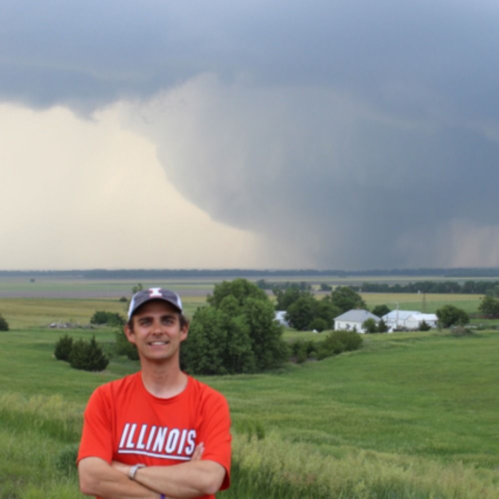
Day #13: Surprise structure fest in southwestern Kansas and the Oklahoma Panhandle, a large sunset wall cloud, mammatus, and a non-photogenic landspout (not shown). What a day! #AlwaysKansas

1 replies 0 reposts 8 likes


Jeff Frame's avatar Jeff Frame @vortexjeff.bsky.social
[ View ]

Day #12: Cap bust in western Nebraska.

1 replies 0 reposts 5 likes


Jeff Frame's avatar Jeff Frame @vortexjeff.bsky.social
[ View ]

Day #11: Watched a beautiful slow-moving LP supercell develop from a towering cumulus cloud and then dissipate over 2+ hours. Great chase!

0 replies 0 reposts 11 likes


Jeff Frame's avatar Jeff Frame @vortexjeff.bsky.social
[ View ]

Day #10: Observed storms near an outflow boundary in southeastern Nebraska. They looked pretty for a while, but quickly became outflow dominant

1 replies 0 reposts 3 likes


Jeff Frame's avatar Jeff Frame @vortexjeff.bsky.social
[ View ]

Day #9: The van was fixed just before noon today, so we drove from Minnesota to Lincoln, NE, to position for Saturday. Even without the van problem, we likely would have passed on today anyway given the distance and quality of the target.

0 replies 0 reposts 3 likes


Jeff Frame's avatar Jeff Frame @vortexjeff.bsky.social
[ View ]

We got the van fixed this morning and drove to Lincoln, NE.

0 replies 0 reposts 1 likes


Jeff Frame's avatar Jeff Frame @vortexjeff.bsky.social
[ View ]

Day #8: Unfortunately, we had a low-speed collision with a deer at the end of the chase Wednesday. Everybody is fine, but the vehicle needs some work. We spent the day in Willmar, MN.

2 replies 0 reposts 3 likes


Jeff Frame's avatar Jeff Frame @vortexjeff.bsky.social
[ View ]

Day #7: Observed a supercell in western Minnesota that eventually exhibited nice structure.

0 replies 0 reposts 6 likes


Jeff Frame's avatar Jeff Frame @vortexjeff.bsky.social
[ View ]

I agree! Terrain ahead of that cell doesn't look impossible but not as nice as south of 94

0 replies 0 reposts 1 likes


Jeff Frame's avatar Jeff Frame @vortexjeff.bsky.social
[ View ]

I haven't actually. We're just up the road in Benson watching the OFB and towers to the west.

1 replies 0 reposts 1 likes


Jeff Frame's avatar Jeff Frame @vortexjeff.bsky.social
[ View ]

Day #6: Down day. Toured Badlands National Park, ate lunch at Wall Drug, and drove to Sioux Falls to position for tomorrow

0 replies 0 reposts 4 likes


Jeff Frame's avatar Jeff Frame @vortexjeff.bsky.social
[ View ]

Day #5: After talking ourselves out of a potential bust in central Wyoming, our initial supercell near the Wyoming/ South Dakota border quickly became outflow dominant and then it was shelf cloud time.

0 replies 0 reposts 6 likes


Jeff Frame's avatar Jeff Frame @vortexjeff.bsky.social
[ View ]

Day #4: Chased a marginal risk near Kaylee, Wyoming, today and saw a marginal supercell, a funny looking lowering, and a shelf cloud. Also hiked around Casper and saw a waterfall

1 replies 0 reposts 3 likes


Reposted by Jeff Frame

Weather History's avatar Weather History @weatherhistory.bsky.social
[ View ]

June 8, 1947: An estimated F4 carved a 20-mile path near Sterling, Colorado. The monstrous vortex reached a width of around a mile and devastated 20 farms, sweeping away many structures. This event was likely Colorado's most violent tornado. 3 people were injured.

0 replies 2 reposts 6 likes


Jeff Frame's avatar Jeff Frame @vortexjeff.bsky.social
[ View ]

Day #3: Observed a supercell thunderstorm near Hereford, CO, before rapid upscale growth and then saw a bonus storm in Wyoming later.

2 replies 0 reposts 9 likes


Jeff Frame's avatar Jeff Frame @vortexjeff.bsky.social
[ View ]

Day #2: Observed two beautiful supercells for hours in central Nebraska

1 replies 0 reposts 12 likes


Jeff Frame's avatar Jeff Frame @vortexjeff.bsky.social
[ View ]

Day #1 (Thursday): Down day. Drove from Champaign-Urbana to Grand Island, Nebraska

0 replies 0 reposts 4 likes


Jeff Frame's avatar Jeff Frame @vortexjeff.bsky.social
[ View ]

We're looking at the same choice Sunday. Looks like both targets are viable for a few days, but eventually, you'll have to get north.

1 replies 0 reposts 1 likes


Jeff Frame's avatar Jeff Frame @vortexjeff.bsky.social
[ View ]

We head west tomorrow. We're passing on Oklahoma for numerous logistical and meteorological reasons. Very likely chasing Nebraska Friday and then CO/WY(?) upslope Saturday. This pattern would never work in April/early May. A bit big troughed out after our last excursion

2 replies 0 reposts 2 likes